Touring the Thompson/Shuswap Corridor
Chasing Waterfalls | Spring, Summer, or Fall | Weeklong Road Trip

Battle Bluff, Kamloops | Destination BC/Andrew Strain
“WEYT-KP”, welcome to the unceded lands of the Secwepemc (suh-Wep-muhc or Shuswap Nation).
This Indigenous-inspired road trip takes you from the Rocky Mountains' highest and most inimitable peak to the historic village of Chase, BC. Give yourself at least 7 days to fully experience the essence of this beautiful journey.
A traveller is one who “immerses themself in the places they visit.” Responsible travellers plan, choosing experiences that leave a small ecological footprint. Our road trips are packed full of culture, and we encourage you to stop in rural or Indigenous communities, stay in locally run accommodations, eat and sip at small shops, and buy from local artisans.
Our trips are all connected, but you can experience them independently or combine to create the adventure of a lifetime!
Kukwstsétsemc (Thank you)
The Vagabonds.
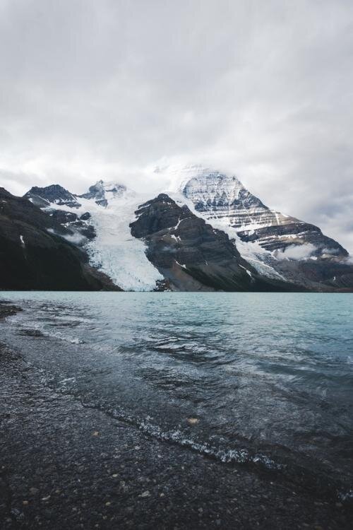
Mount Robson Provincial Park
2-3 days for beginner to moderate explorers
Near the Continental Divide, in Mount Robson Provincial Park, you will find a small, backcountry stream; a trickle of water just six inches wide and one finger deep. This is the humble beginning of the mighty Fraser River. The ambitious, spring-fed water runs through the Robson Valley between the Rocky Mountains’ North Continental Range and the Cariboo Mountains before joining the glacier-fed Robson River.
Here, in the crown jewel of Canada’s National Parks system, you will find Mount Robson. At 3,954 metres, this majestic mountain is the highest peak in the Canadian Rockies and an epic challenge for climbers from around the world.

Highway 16, Mt Robson | Destination BC/Jongsun Park
Part of the Canadian Rocky Mountains World Heritage Site, this protected land is a pristine and diverse wildlife corridor. It is considered by the Secwepemc people to be a sacred place; to the locals, it is simply Mother Nature’s finest masterpiece.
Simpcw First Nations of the Secwepemc Nation have roamed these ancestral and unceded lands throughout ancient history. Their semi-nomadic ways of hunting, fishing, and gathering followed the seasons and the timing of caribou and salmon migration. The “Texqakallt Nation”, the area's earliest known inhabitants, called Mount Robson “Yuh-hai-has-kun” or “The Mountain of the Spiral Road”- referring to the layered appearance of the huge peak.
The trails and paths we now follow were once important hunting and gathering or trade routes for Indigenous people. Today, Berg Lake Trail is one of Canada's most coveted multi-day hiking adventures.

Mt Robson Provincial Park | Destination BC/Megan McLellan
Berg Lake Trail - Overnight Excursions or Day Hikes
People from all over the world do this hike – and it’s no wonder. The journey is a pilgrimage through sacred lands, natural wonders and changing landscapes, that lead travellers through three bio-geoclimatic zones.
If you are hiking right up to Berg Lake or beyond, you will want to camp at least one night as it’s about 42 kilometres round trip from the trailhead to Berg Lake Campground. Completing the entire trail in one day is doable, but only for experienced hikers or trail runners.
If you’re not a trail runner, make sure to reserve a campsite ahead of time - the cost is $6 - $18/night (plus backcountry fees of $10/night). Book well in advance because close to 4,000 backpackers visit each year!
The trail is just over the Alberta/BC border, west of Jasper. To get an early start, we recommend staying in Mount Robson Park the night before at an Airbnb – or in Valemount, BC, about 30 minutes south.

Berg Lake Trail Map | Download Here

Mt Robson | Destination BC/Robert Downie
Before heading out on the hike you will need to sign in at Mount Robson Visitor Centre (open May-September). You will get a brief safety orientation and a permit to camp. Keep this handy in case Rangers ask to see it. The trailhead and parking are just 2 kilometres from the Visitor’s Centre.
The trail starts with a wide bridge across the Robson River. You will make your way gradually uphill through a temperate rainforest filled with ancient cedars, hemlocks and ferns. Inhale the fragrance of the forest, it will change as you explore the Park.
The first milestone along the trail is Kinney Lake, which is a perfect 3-hour family hike (about 7 kilometres from the trailhead.) The brilliant blue colours of the glacial-fed water comes from natural sediment. This is the furthest you can go on a bike. There is also a campground here – the first of 7 campsites along the hike.

Trail Approaching Kinney Lake | Destination BC/Steve Ogle
If you have the time and energy, continue onwards. It’s well worth it as views begin to open to the valley around you. The next milestone is Whitehorn Campground, which is about 4 flat kilometres from Kinney Lake. The elevation here is 1,097 metres so make sure to hydrate often.
Take a deep breath; you are less than a kilometre away from the viewpoint of Valley of a Thousand Falls - one of the planet's most intense and exquisitely woven tapestries of rivers, lakes, and streams. The impressive White Falls, Falls of the Pool and Emperor Falls are the gems of the valley, but make no mistake, there are abundant treasures waiting around the next bend! Stop for a picnic here if you can; the trail is about to get even more challenging.
After the first few switchbacks, you will reach a viewpoint where you’ll observe the power of White Falls as it cascades over the canyon. Continue another kilometre uphill to Falls of the Pool viewpoint. This is the best location to observe the two tiers of the falls; the first taking a dramatic plunge of 43 metres into a small cerulean pool before cascading another 11 metres into the depths of the canyon.
You are now at an elevation of 1,370 metres. Another 2 kilometres and you’ll reach the spectacular Emperor Falls which plunges 46 metres into a thundering spray of water and mist. You will have to veer off the trail to see the falls, but it’s less than half a kilometre and well worth it to watch the stunning glacier water cascading down around you.

Emperor Falls on the Berg Lake Trail | Destination BC/Brayden Hall
Emperor Falls Campground is another half a kilometre uphill next to the Robson River. Reservations book up quickly as there are only 9 campsites.
From here it’s only a few more flat kilometres to the shores of beautiful Berg Lake and Marmot Campground, another great option for your first night. As you walk along, look up for Berg Glacier as it crashes into the aquamarine waters of Berg Lake.
The next section of the trail, leading from Marmot Campground to Berg Lake Campground, is fairly flat, with stunning views of the glacier through the towering trees.
Berg Lake Trail, Mt Robson Provincial Park | Destination BC/Brayden Hall
From Marmot or Berg Lake Campground, there are some amazing day hikes, if you are able to spend an extra night on the trail. One of our favourites is the Toboggan Falls loop, a 2-hour round trip from Berg Lake Campsite. There are some incredible views of Mount Robson, Berg Lake and Toboggan Falls, which is a series of cascading waterfalls. At the top of the falls there’s a bench with a great viewpoint and a perfect spot for a picnic!
If you plan to continue to the end of Berg Lake Trail, there are two more campgrounds – Rearguard and Robson Pass. The trail goes all the way to the Jasper National Park boundary, which is 23.3 kilometres and 1,655 metres elevation. We only recommend going this far if you are an experienced hiker.
There are a few day-use shelters along the way for cooking and wash stands for doing dishes. There are also lockers in all the campsites for storing food and toiletries, or our Responsible Travel Boxes when they’re not in your pack.
Remember, you are in ancient and protected lands that are home to a vast number of plant and animal species and ancient artifacts. Pack out what you pack in and take only photos, leaving what you find for others to discover. If you come across a significant discovery, contact the Visitor Centre or Parks Canada.
Fun Facts:
Mount Robson has earned the nickname the “Great White Fright” as roughly only 10% of mountaineers who attempt to climb Robson are successful.
In the Winter:
Ice fishing, snowshoeing, and hiking
Cold Fire Creek Dogsledding offers amazing moonlight adventures, and allows visitors to steer the sled!
Note: Travelling BC Highways in the winter requires the use of appropriate tires, and a four-wheel drive is strongly recommended. Pack a safety kit including warm blankets, snacks and water. Some travellers choose to carry chains through these areas.
Wells Gray Provincial Park
1-2 days for beginner to moderate explorers
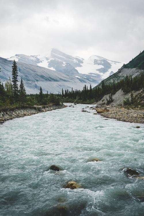
After leaving Mount Robson, take Highway 16 to Highway 5 and head south towards Kamloops into Wells Gray Provincial Park.
A trip to Wells Gray isn’t complete without a visit to the world’s longest salmon run at George Hicks Regional Park. The journey of salmon at Bailey’s Chute is one of the most epic natural sagas to unfold each fall. Chinook Salmon travel over 600 challenging kilometres to reach their spawning ground, and their last bit of effort is used to spawn before they die. Serving witness to these incredible creatures battling the odds is both heartbreaking and inspiring, as life in the wild often is. The Chute is located approximately 59 kilometres along the Clearwater Valley Road from the Wells Gray Park and Clearwater Information Center. The best time to view the salmon would be early morning and evening.
A visit to the second salmon viewing platform on the Raft River, just outside of Clearwater, provides a unique perspective of the landscape and allows one to witness the return of the Sockeye Salmon to their annual spawning grounds. Sockeye spawn in streams with lakes in their watershed and stay in those lakes for 1-3 years before migrating to the Gulf of Alaska and North Pacific Ocean where they feed. Chinook Salmon migrate upstream from spring through fall as far as 1,500 kilometres inland. You can observe both types of salmon migrating up the Fraser River through the rivers and streams of Wells Gray Park.
The Raft River platform overlooks the site where the Simpcw people, like the salmon, return each year to fish using traditional methods like gaffing and seine netting. The traditional fishing methods are both efficient and sustainable. The Secwepemc ensure enough salmon make it to the spawning area to maintain the strength of the run - in contrast to the early settlers, miners, and loggers who blocked passage to the fish and damaged habitat.
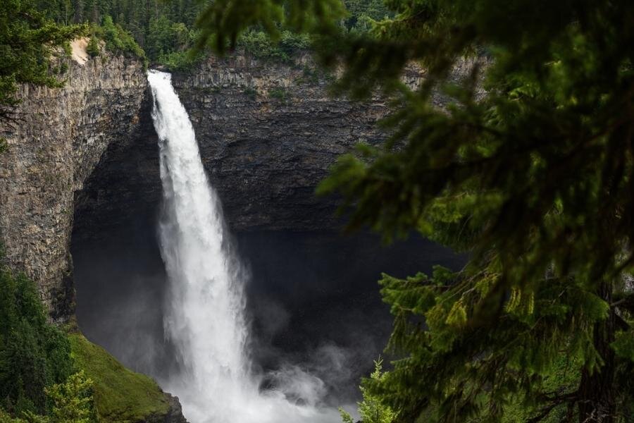
Helmcken Falls, Wells Gray Provincial Park | Destination BC/Andrew Strain
Known as Canada’s “Waterfall Park,” the stunning 1.3 million acres of wilderness, created by volcanoes and carved by glaciers, is a natural wonder. The crown jewel of the park is Helmcken Falls – the fourth highest waterfall in Canada. This is a 45-minute detour north of Clearwater, but well worth it!
There’s a viewpoint near the parking lot, but we recommend making the 8-kilometre hike through the ancient rainforest up Rim Trail.
The interior rainforest is an unlikely treasure and deeply rooted in the culture of the Secwepemc people. Only two other temperate rainforests exist in the world; one in Russia, the other in southern Siberia. A hidden gem, the rainforest shelters many at-risk species such as southern mountain caribou, wolverine, goshawk, and bull trout, which spawn in cool, sheltered streams in two of the forests' old-growth valleys.
We also encourage you to visit Moul Falls, a 1-hour hike from Clear Water Valley Road. The simple trail takes you to the edge of Grouse Creek where the water careens into the Clearwater River. You can stand in the cave directly behind the falls. An incredibly unique experience!

Photo: Natasha Pellatt
It is from this majestic wilderness that the Clearwater, Murtle, and Mahood Rivers join the North Thompson River and continue to their confluence with the mighty Fraser. It’s also where the Rocky Mountains, Cariboo, and the Monashee Mountains converge in a landscape of unbridled splendor.
To get up close and personal with the power of the water, book a rafting excursion through the churning waters of "Mother Nature’s Roller Coaster” on the Clearwater River.
If you have a canoe or kayak, Clearwater Lake is a calm alternative and beautiful spot to enjoy the peacefulness of the wilderness.
Over 50 archaeological sites have been discovered in the area including sacred pictographs on the shores of Mahood Lake. We love spending time looking for remnants of ancient kekulis, now resembling little more than grass-covered mounds dotting the ancient wildflower meadows.
As you leave the Park you may want to make an offering to the waters that bring life to the people and place that call this magnificent place home. Indigenous Knowledge Keepers and Elders offer tobacco in a sacred ceremony. We hope you offer your gratitude for your experience and hopes for the preservation of these lands and its waters - as together, we place pressure on our government to provide fresh, accessible drinking water to all First Nations communities across Canada.

Murtle River plunges over Dawson Falls | Destination BC/Andrew Strain
Fun Facts:
There are over 100 lakes well-stocked with a variety of fish within an hour of Clearwater.
In the Winter:
Explore 85 kilometres of Nordic or cross-country trails. (The Wells Gray Outdoor Club maintains the Candle Creek Ski Trails spanning 28 kilometres)
Ice fishing, snowshoeing and hiking
Guided snowshoeing tours of the area’s waterfalls. Check out Riverside Adventures Ltd.
Note: Travelling BC Highways in the winter requires the use of appropriate tires, and a four-wheel drive is strongly recommended. Pack a safety kit including warm blankets, snacks and water. Some travellers choose to carry chains through these areas.
Vagabond Pick
• One of the best self-contained campsites in the area is Robson Meadows. With 120 sites alongside the riverbank, it’s close to the Mt. Robson Visitor Centre with easy access to Berg Lake Trail. Well protected by trees, there is an on-site store and restaurant. Accessible by vehicle and open May 15 – September 30.
Where to Eat:
Three Ranges Micro-Brewery - Valemount
Caribou Grill – Valemount
The Riverside Café – Valemount
Hop “N” Tap and Smokehouse – Clearwater
Double R Pizza and Subs - Clearwater
please review Clearwater EATS to confirm operations.
Need to Know:
Near the northern Parks, Clearwater is your last opportunity to fuel-up and grab snacks.
Cell service is unpredictable in many park areas so plan ahead. Bring a compass too, and remember that moss always grows on the north side of the trees.

Views over Kamloops | Destination BC/Andrew Strain
Kamloops Culture and Wine
1 day with an overnight stay
After experiencing the pristine abundance of Mount Robson and Wells Gray Provincial Parks on the unceded lands of the Secwepemc, it’s important to learn about the impact European contact had on the lives of these peaceful, semi-nomadic people.
The Secwepemc Museum and Heritage Park, located in the notorious Kamloops Residential School, is closed following the discovery of the bodies of 215 Indigenous children discarded in a mass burial pit on the property. Operating until 1977, the racially misguided consequence of the Residential School System resulted in the near cultural genocide of a people as their children were stolen from their family, their homes, stripped of their lands, and denied their heritage.
Under the veil of religion, the seeds of systemic racism were planted in British Columbia. From the 1880s to the mid-twentieth century, the annihilation of Indigenous culture and language flourished across the country. The Residential School Tour of the Museum includes a visit to the fourth floor of the school, the boys' dormitory. It includes a film presentation and guided tour of carefully curated exhibits, putting this dark period in its proper historical context. Following the tour, visitors are invited to participate in an educational discussion.
The museum offers a “The Precontact Tour” that teaches about traditional Secwepemc life and includes important information on local Indigenous knowledge and culture. Check out the museum’s hours before stopping by and make a small donation if you can.
In the mood for pizza? Check out Bold Pizzeria - a Naples-inspired local gem. They make and bake pizzas fresh and have a few quirky offerings if you’re feeling adventurous.
Cordo Resto & Bar is a contemporary spot, offering Canadian-inspired, vegan, and gluten-free options. The team at Cordo celebrate the flavours of the region through locally sourced food and handcrafted spirits.

Downtown Kamloops at Victoria & 1st Avenue | Destination BC/Tanya Goehring
After dinner, take a stroll on Riverside Park pathway to Pioneer Park near the confluence of the North and South Thompson Rivers. There’s a sandy beach to dip your feet in, a boat launch for your kayak, and a view of Red Bridge.
In the morning grab a hearty breakfast at Hello Toast before heading out on the Kamloops Wine Trail, home to Harper’s Trail, Monte Creek Ranch Winery, and Privato Vineyard & Winery.
The region is gaining a respected reputation for producing crisp white wines, vibrant sparkling wines, and light, fruit-forward reds. The Thompson Valley Wine Region was officially granted a geographic wine designation (GI) in 2018. The regional boundary parallels the Thompson River watershed and runs approximately 130 kilometre east to west starting at Chase and ending at Cache Creek.
The Thompson-Shuswap wine country is home to a dozen vintners that are winning awards for their handcrafted cool-climate varietals such as Ortega, Maréchal Foch, and Siegerrebe.
Fun Facts:
The Gore archeological site near Pritchard is home to human remains dating to 8250 BCE. There is also an old wooden single-lane bridge that crosses the river; it is worth a stop to visit the vintage corner-store and walk across the bridge.

Sun Peaks Resort | Destination BC/Reuben Krabbe
In the Winter:
Ski Sun Peaks - Canada's second-largest ski resort
Cross-country ski or snowshoe at Stake Lake
Ice fish with Elevated Fishing Adventures
Note: Travelling BC Highways in the winter requires the use of appropriate tires, and a four-wheel drive is strongly recommended. Pack a safety kit including warm blankets, snacks and water. Some travellers choose to carry chains through these areas.
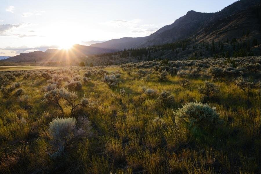
Lac du Bois Grasslands | Destination BC/Andrew Strain
Places to Stay:
Where to Eat:
Hello Toast – Kamloops
Bold Pizzeria - Kamloops
Cordo Resto and Bar - Kamloops
Passek’s Classic Restaurant and Bakery - Kamloops
The Shuswap Pie Company – Salmon Arm
Barley Station Brew Pub – Salmon Arm
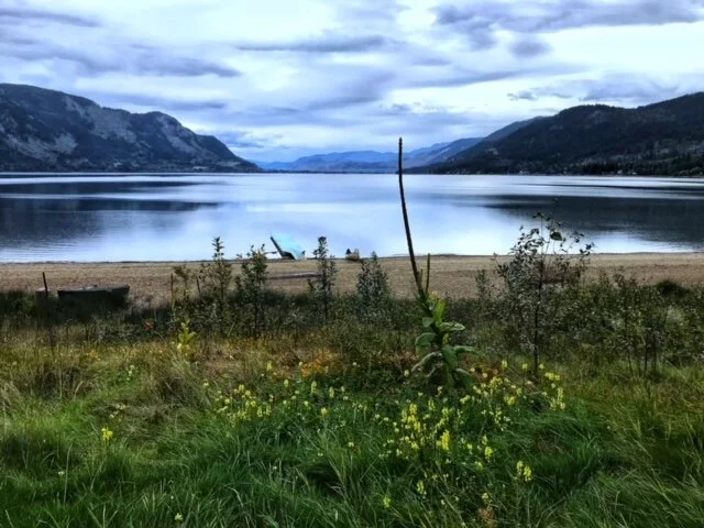
Chase B.C – The Hidden Gem
2 days with side-trips around the area
Chase BC (Quaaout in Shuswap) is an inviting little lakeside village of about 2,500 people, just 45 minutes east of Kamloops. The intimacy of the community helps preserve its rich, humble heritage with locals passing Indigenous legends down through generations.
Unfortunately, Quaaout Lodge is temporary closed due to fire. The Talking Rock Golf Course and cultural tours of the property are still available upon request and we encourage you to support this destination through their rebuilding process. We have left our description of the Quaaout experience posted in honour of the legacy of Quaaout Lodge, one of our favourite resort stops in British Columbia. Enjoy locally sourced food handcrafted by award-winning Chef Chris Whittaker and play a round on the 18-hole golf course, Talking Rock. The on-site spa, archery, and beach are amazing assets with the resort surrounded by hiking and biking trails. Pets are welcome too!
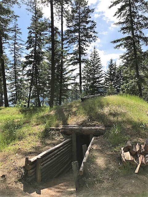
The Cultural Centre at Quaaout Lodge gives visitors a glimpse into the Indigenous heritage of the region. From guided tours, drum-making classes, and paddles out to sacred pictographs – the experience is unique and spiritual. We recommend making time to see the kekuli (Indigenous winter home) and sweat lodges.
Ts’utswecw Provincial Park is close to Quaaout Lodge and also on Secwepemc lands. The park used to be called Roderick Haig-Brown Park and is best known for The Salute to the Sockeye. event hosted by The Adams River Salmon Society. During the dominant years of the run (the next dominant cycle is in 2022) a visit to the viewing platform is a must, to observe millions of salmon completing their epic journey! The best viewing time is mid-September through October.

Salmon in the Adams River | Destination BC/Josh Humbert
The Adams River squeezes through a narrow canyon portion of the valley, creating tumultuous rapids used by experienced rafters and white-water kayakers. The park shelters a variety of heritage and cultural sites. Recent archaeological studies have uncovered evidence of large Indigenous settlements dating back to 1649 A.D. Long before the arrival of Europeans, thousands of people formed villages along the waterways of the area. Kekulis (pit houses), artifacts, and pictographs can be seen but access is strictly prohibited and if you do discover an artifact, arrowhead, or tool – we ask you to please leave it where it is and notify the local Park Authority.
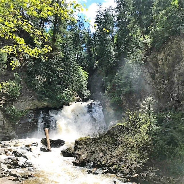
There are several historic hikes in the park. The Flume Lake Trail is an easy one to follow with five unique bridges crisscrossing the water offering impressive views of Bear Creek Falls and old world-forest growth that was not lost to logging.
The Turtle Valley Donkey Refuge is a delightful stop. One can visit charming equine refugees as they peer curiously through an ageing wooden fence. Once abused and abandoned donkeys, mules, and ninnies freely roam the property. There is a slight entry fee used to fund the shelter.
Turtle Valley Bison Company, surrounded by sloping hills and forests that are home to black bears, birds and bees, coyote and cougar, are where the bison roam free. Through the meadows and grasslands, down by the lake, you'll find them playing a crucial role in balancing the ecosystem of this responsibly operated and holistic zero-waste ranch.
In season, you can partake in a unique culinary adventure, called Ranch Fest. For “meat-loving, beer-drinking people, and wine fanatic foodies who want to tantalize their taste buds”. Ranch Fest is a multisensory experience curated to celebrate the terroir and history of the area. Guests can explore the trails, lounge by the fire, or take a stroll around the lake, if you are lucky you might just be invited to forage for your food.
If you want a birds-eye view of the Valley, Treetop Flyers Zipline (please contact to make sure this experience is open for visitors) soars high above Chase Falls and the scenic canyon corridor home to local Mountain Goats and skinny-dippers. Take a ride on the solar-powered "Screaming Eagle Swing. Trust us, this is an experience like no other! It’s a slow crank to 100 feet, followed by a full strung archer’s release. We compare it to an eagle swooping for prey!
Centennial Park Beach breasts the shores of the village and is home to the now rebuilt 300-meter wharf. The Village, its beaches, and boundless activities are family fashioned and activity focused. Check out the local hiking trails, lazy river floats, paddling, cycle paths, and local skateboard park.
The last experience on our epic weeklong road trip involves “chasing waterfalls”. Venture off the beaten path where a short walk through a tunnel underneath the TransCanada Highway off of Paquette Road brings you to a lovely little waterfall, and one of the areas hidden gems – Chase Falls. Dropping a mere 10 metres into an inviting pool it makes its way through the ponderosa pines and sprawling ferns before flowing into Little Shuswap Lake on its way to join the tapestry of rivers carving their way south to converse with the Fraser River.
Fun Facts:
On the Chase/Falkland Road there is a small hike that takes you to a 28-metre tall rock known as the Pillar where an 8-ton rock balances on the top of a cynical like base. Indigenous legend says it was placed there as a wayfarer guide by Coyote. Coyote, also known as the Trickster, is an important figure in Secwepemc stories.
In the Winter:
From Nordic and backcountry skiing, snowshoeing, and tobogganing – this is a winter oasis. Secret cross-country and snowshoe trails can be found at Skilometreana Lake on the back road between Chase and the North Shuswap.
For more information contact Skilometreana X-C Ski & Snowshoe
Snowshoe or Cross-Country Ski at Larch Hills Nordic Society
Note: Travelling BC Highways in the winter requires the use of appropriate tires, and a four-wheel drive is strongly recommended. Pack a safety kit including warm blankets, snacks and water. Some travellers choose to carry chains through these areas.
Places to Stay:
The Inn at the Ninth Hole Bed and Breakfast – Salmon Arm
Artists House Heritage B&B - Sicamous
Chase Lions RV Campground – Chase
Quaaout Lodge and Spa – Chase
Where to Eat:
Jack Sam's Quaaout Lodge - Chase
The Railside Restaurant – Chase
Craig’s Bakery and Deli – Chase
Pete’s Pizza and Pasta – Chase
Please check our Responsible Travel Boxes curated with local artisan wares and the planet in mind. Our boxes offer essential road trip items with a twist – they are naturally good for you, the planet, and our economic recovery.